
The Railroad’s Impact on Southern Arizona
Timeline

1853-1855: The Pacific Railroad Surveys sent teams to the American West to search for potential railroad routes to the west coast. Arizona was included in the surveys.
1857: A map of the proposed railroad lines through Arizona is published.
1877: In the spring, the Southern Pacific Railroad stalls at the California border. The Texas & Pacific Railroad was originally contracted to build the railroad through Arizona, but they were far behind schedule. Although they did not have the authority to do so, the Southern Pacific Railroad built a bridge across the Colorado River and brought the first train into Arizona on September 30, 1877. This set off an uproar that first involved Congress, then the territorial legislatures of both Arizona and New Mexico. Ultimately, the Southern Pacific won out over the Texas & Pacific and was granted the contract to build the railroad through Arizona and New Mexico.

In total, about 5,000-6,000 Chinese worked on the southern line. At any one time there were approximately 1,100-1,200 Chinese actively working. Many of the men were veterans of the 1st transcontinental railroad.
November 1878: Construction of the Southern Pacific Railroad finally moves out of Yuma.
December 7, 1878: From the Arizona Sentinel, East of Yuma: “The Chinese are crowded there and work with monotonous industry that reminds one of the ant. These men appear to be neither happy nor miserable, just stolid and indifferent. It is plain that they move dirt more slowly than white men but as they have no pipes to fill and no political reforms to discuss, they manage to get in a fair day’s work before night falls.”
April 1, 1879: The railroad reaches Gila Bend.
Late May 1879: The railroad reached Casa Grande. Because of the lack of supplies and hot weather, construction is suspended for almost six months. During this time some of the Chinese returned to work California, others found employment in Arizona.
January 1880: 300 Chinese arrive in Tucson to work on the Tucson extension.
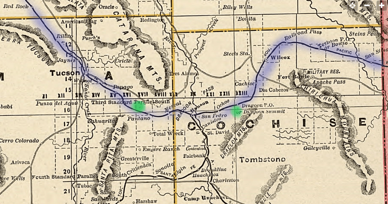
February 1880: Several hundred Chinese had already been dispatched to the difficult areas of Cienega Creek & the San Pedro Valley; the most difficult length of track to lay and to maintain in Southern Arizona. In areas, track had to be laid up a grade (incline). The most difficult and expensive section of track to lay was between what is now Vail east to Dragoon Summit. In addition, the railroad bed had to be raised above the swampy areas along the Cienega Creek.
March 20, 1880: The railroad officially arrives in Tucson!
April 15, 1880: From the Arizona Weekly Star: “In the Cienega a large number of China-men are engaged excavating, as they there encounter considerable elevation through which cuts have to be made, and the grade has to be raised a number of feet above the low, marshy ground…”
Early June 1880: The U.S. census records 850+ Chinese railroad workers in the camp along the Cienega Creek. This was the main group of workers. There were likely isolated crews working ahead (east) of the main group preparing the ground to lay track, as well as crews working behind (west) of this crew, checking the newly laid tracks and doing finishing work on the bridges. They were not counted by the census takers.
September 22, 1880: After laying 384.5 miles of track, the railroad crews move out of Arizona into New Mexico.
1882: The building of the Atchison, Topeka & Santa Fe line from Benson to Calabasas was interrupted when a contractor brought in Chinese laborers to work with the Mexican labors. The Mexicans, who were normally hired to do low wage/high risk labor in southern Arizona, were not happy with the situation. A riot broke out and the contractor was strung up to a utility pole. After he was let down, he promised not to hire any more Chinese. The Chinese at the camp left. Except for the large crew of Chinese who came in 1888 to rebuild the track along the Cienega Creek, the labor used to maintain the railroads in Southern Arizona came from the Mexican population.

January 12, 1883: A Golden Spike was driven at a bridge on the Pecos River joining the eastern and western divisions of the Southern Pacific Railroad.

1880 – 1887 serious washouts: The chosen railroad route east followed that used by the Butterfield Stage (1857-1861). Later, Highway 80 followed the same route and passed through the town of Vail. I-10 also follows the same general route, but it runs farther south of the Cienega Creek. The Southern Pacific Railroad saw benefits to using a route that followed the series of streams in the area south of Vail, but they were ignorant or dismissive of the intense seasonal flooding from the summer monsoons in Arizona. The continual washouts along the Cienega section were bad for business. They cut off the communities who had become dependent on railroad service. There was no mail delivery, no freight deliveries, and no passenger service. Frequently, the railroad washouts also took down the telegraph linesthat ran parallel to the tracks, cutting off outside contact.
1887: A bad year along the railroads in southern Arizona.
>April 27th: Robbery of the Sunset Express passenger train took place about 17 miles east of Tucson (near the Pantano Station) by the Doc Smart gang.
>May 3rd: A major (7.2-7.5 on the Richter scale) earthquake hits Southern Arizona. There are rock falls & some damage to railroad lines in far southeastern AZ
>August 10th: Because the first robbery went so well, Doc Smart robs the same train, at the same location. This time the engine jumped the tracks and flipped over.
>September – A massive storm causes a severe washout along Cienega Creek. Railroad ties are washed as far north as Fort Lowell, which is at the confluence of the Pantano & Rillito Creeks at the base of the Catalina foothills; approximately 30 miles away.
January – August 1888: A work gang of 1,000 Chinese returns to the Cienega Creek to relocate sections of the railroad track to higher ground. In addition, earthen berms were built between the creek and the railroad track to keep the creek away from the tracks.
The Railroad’s Impact on Southern Arizona
Just as it had in the Great Plains, quick & efficient transportation of Army troops ended the Indian War in southern Arizona. Camp Bowie was established as an army camp in 1862 by the California Volunteers on their way to New Mexico. In 1880 railroad track was laid approximately 15 miles to the north of Fort Bowie. When Geronimo surrendered in 1886, he was taken to Ft. Bowie. From there he was sent into exile on railroad tracks laid by the Chinese. Thousands of years of a Native American presence in Southern Arizona was over.
Once the mining companies were freed from dependence on mule trains, the mining industry flourished. Growth of the mining industry depended on the trains to get the heavy equipment into the ore rich areas and to ship out tons of ore for processing.
Ranchers could get cattle quickly and easily to market. Ranches like the Empire Ranch, owned by Walter and Edward Vail, John Slaughter’s San Bernardino Ranch, now known as the Slaughter Ranch, were able to grow beyond the limits of cattle drives when they were able to get more of their stock to market by railroad. By the 1930s Willcox was the top cattle shipping station in the US and was known as “Cattle Capital of the World.” Because of the ability to ship more cattle, more cattle were raised than ever before. The land in southeastern Arizona, once famed for its extensive grass lands, became over-grazed. It has never recovered.
Tucson changed from a Mexican village into an American city connected to the rest of the United States by both rail and telegraph.
Towns such as Benson and Willcox grew up along the railroad line. Closer to Tucson, Vail experienced a boom time when the Helvetia Mining company built a road to Southern Pacific Railroad siding in 1899 to accommodate the shipment of copper ore. Business increased along with the population. In 1901 the Southern Pacific Railroad built a passenger depot that also served as a Class IV U.S. Post Office. Vail’s siding and became known as Vail’s Station. In 1912 the El Paso & Southwestern Railroad extended their main line parallel to the Southern Pacific Main Line and Vail became known as “The Town Between the Tracks.” In 1903 the Vail School District formed, and postal services moved to Vail’s store located across the tracks from the Vail Depot. Vail now had a railroad house for the Vail Section Foreman, a Section House for maintenance crew members and the population had grown from about 20 to over 100! As ore and cattle shipping shifted to other locations Vail’s population dropped. By about1950 the train no longer stopped, and Vail’s Depot was demolished in the 1960s. Its Section Foreman House was sold and moved to another location. During much of the 20th Century Vail was a quiet, rural ranching community. In 2021, fueled by rapid housing development, Vail is once again a growing, thriving community that works to preserve its interesting past. (A thank you to J. J. Lamb of the Vail Preservation Society for her assistance.)

Resources
See also: Railroad Bibliography
Ayers, James. James Ayers Newspaper Index: Early Southern Arizona Newspaper Index 1859-1911: Topic: Southern Pacific Railroad, viewed on 9/12/2022 https://arizonahistoricalsociety.org/wp-content/uploads/2019/05/library_Ayres-Index_Southern-Pacific-Railroad.pdf
Angela Cotey, Angela. “Cienega Creek, Arizona,” Trains, October 19, 2020, last updated on November 3, 2020, viewed on 1/6/2025 https://www.trains.com/trn/railroads/hotspots/cienega-creek-ariz/
Cram, George Franklin. Railroad and County Map of Arizona, 1887, viewed on 9/12/2022 https://www.loc.gov/resource/g4330.rr001820/
Gray, A. B. and Sylvester Mowry. Map of Proposed Arizona Territory, Cin[cinnati], Middleton, Wallace & Co. Lithos, 1857, viewed on March 25, 2022 http://hdl.loc.gov/loc.gmd/g4301p.rr001720 Includes proposed railroad lines through the Territory as of 1857.
Janus Associates Incorporated. Transcontinental Railroad in Arizona: 1878-1940, A Component of the Arizona Historic Preservation Plan, Arizona Historic Preservation Office, December 1989, viewed on 9/12/2022 https://d2umhuunwbec1r.cloudfront.net/gallery/0004/0051/0C6E6492BD8A49D7B4D3FA9DD45E54CA/Transcontinental%20Railroading%20in%20Arizona%201878-1940.pdf
Lamb, J. J. “The Arrival of the Southern Pacific Railroad at Vail: It’s Influence on the Development of a Community,” Arizona Centennial Conference, April 2012. (Arizona Historical Society Library & Archive, Tucson, AZ Arizona Historical Convention, 2012 Collection.)
Myrick, David F. “Railroads of Southern Arizona: An Approach to Tombstone,” Journal of Arizona History, Vol. 8, No. 3 (Autumn 1967). This article focuses on after the Southern Pacific Railroad was built.
Myrick, David F. The Southern Roads, Series: The Railroads of Arizona, Vol. 1, Howell-North Books, 1975.
Roskruge, George J. Official Map of Pima County, “Adopted as the official map of Pima County by resolution of Board of Supervisors, July 22, 1893,” viewed on 9/12/2022 https://www.loc.gov/resource/g4333p.la000006/
Skyview FPV. Three Bridges at Cienega Creek, YouTube, September 27, 2016, viewed on 9/12/2022, https://youtu.be/i13g1Y3g8O8 Wonderful drone footage of the Cienega Creek and the railroad tracks that run by it.
Vail Preservation Society. “The Southern Pacific Railroad & The Transformation of Tucson,” Vanished Vail, Episode 15, viewed on 11/18/2024 https://youtube.com/watch?v=Z01dyA3HF84&feature=shares
Vail Preservation Society. “Through the Fire: Chinese Railroad Workers & The Transcontinental Railroad,” Vanished Vail, Episode 16, viewed on 11/18/2024 https://youtube.com/watch?v=oN-klriIxzU&feature=shares
Vail Preservation Society. “Through Marsh & Mountain: Chinese Railroad Workers in Southern Arizona,” Vanished Vail, Episode 17, viewed on 11/18/2024 https://youtube.com/watch?v=URowVCALx1s&feature=shares
Vail Preservation Society. Water Boys: Helping Their Community, 2022, viewed on 11/18/2024 https://youtu.be/YBhYUgFOoe0 “Educator Resources,” including a lesson plan, work sheet and the final presentation are at https://www.vailpreservationsociety.org/teacher-resources